Repost from UNCG NOW
Paleontologist Robert Anemone’s wrong turn turned out to be a happy accident that led him to a rich cache of 50 million-year-old fossil mammals. That was back in 2009 as he and his team from Western Michigan University explored a remote, 10,000-square-kilometer region of badlands in southwestern Wyoming known as the Great Divide Basin.
“Every paleontologist has a story like that,” he says. “They’re like urban folktales except they’re true. We’re out there walking and searching for 8-10 hours a day, and sometimes when we find our best things, serendipity plays a large role. And its always been that way, as far as I can tell, in the history of paleontology.”
Rather than leave future discoveries to chance, Dr. Anemone, who now heads UNCG’s Department of Anthropology, is pioneering a high-tech method of fossil hunting. Teaming up with a geographer and remote-sensing specialist, Anemone is harnessing satellite imagery and artificial intelligence to train computers to help find fossils.
Finding a fossil in the Great Divide Basin is akin to finding a needle in a haystack. Paleontologists like Anemone typically spend a month in the field every summer, often with a crew of 8-10 undergraduate and graduate students and colleagues. But with the enormous size of the basin, deciding where to search for fossils has traditionally been a matter of following dusty two-track roads in search of deposits that may or may not contain fossils.
In 2009, after taking a wrong turn down an unfamiliar road that disappeared in some tall sagebrush, Anemone’s team was lucky to find a fossil-laden sandstone deposit, which they dubbed “Tim’s Confession” after Tim Held, the graduate student who found the first fossils there. Within an hour or two of collecting fossils, Anemone knew his team had literally stumbled upon one of the richest fossil mammal sites of this antiquity in the American West.
Late one night in camp shortly after they found Tim’s Confession, Anemone and his crew found themselves gazing at the spectacular night sky high above the Wyoming wilderness. Among the millions of stars, dozens of constellations, and magnificent horizon-to-horizon display of the Milky Way, they noticed a satellite crossing the sky. And an idea crossed Anemone’s mind.
Might the satellite imagery of the basin, coupled with state-of-the-art approaches from the geographic sciences, improve their odds of finding other fossil deposits? He contacted Jay Emerson, a geographer at Western Michigan, and together they developed a computer model to analyze Landsat imagery of the basin in order to predict other areas that most closely matched the “spectral signature” of their known fossil-bearing locations.
Anemone returned to the Great Divide Basin in 2012 and 2013 to test their model. His team found fossils at 25 of 31 areas identified by the computer model, a much higher success rate than they were used to based on their earlier work in the area. In July, they’ll return with a new fossil-finding tool, an unmanned aircraft or drone, “armed” with an HD video camera that can wirelessly relay high-resolution images of fossil bearing deposits in real-time.
For paleontologists, the first question is where to search. “Traditionally paleontologists have just said, ‘Well let’s go down this road and take a look.’ But our work suggests there is a better way,” Anemone says. “It took us 15 years to find this incredible locality that is Tim’s Confession, and I can’t afford to wait 15 more years to find another one. I want to improve my odds.”
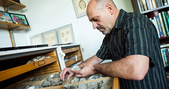
Anemone has been digging in the Great Divide Basin since 1994, turning up a wide variety of Eocene mammals. His lab and his office on the fourth floor of the Graham building, are a repository for the jaws and teeth of Eocene mammals (including some of the first rodents, horses, primates and carnivores), reptiles (like crocodiles, turtles, lizards and snakes) and fish. The fossils date to 50-55 million years ago, at the boundary of the Paleocene and Eocene eras.
The events of that time period hold important implications for today’s world. The Paleocene-Eocene boundary was a time of major global warming, with global temperatures rising by five degrees Celsius or more over a few thousand years. “It’s such an interesting time period for the evolution of primates and many other animals that had to adapt to the changing environment,” he says.
Anemone’s work at the Basin this summer is supported by a $180,000, two-year National Science Foundation grant. In addition to their use of the drone, they want to create a 3D model of the Tim’s Confession sandstone deposit to better understand how this incredibly rich fossil site was formed. He hopes that modern technologies and tools from the geospatial sciences can help him find answers to his questions.
“We’re at the leading edge of applying this stuff to paleontology,” he says. “We’re pushing the field in a new direction.”
Anemone and Emerson wrote about their work for the May issue of Scientific American. Click here to access that article and a slideshow of Anemone’s images from the Wyoming expedition.
Story by Michelle Hines, University Relations
Photography by David Wilson, University Relations